About Our Maps
GPS Trailmasters has enhanced snowmobile and ATV trail navigation by developing a user friendly snowmobile and ATV trail map that is compatible with Garmin GPS devices. Our Garmin GPS maps are compatible with most Garmin GPS units. Our trail map data is also available in KMZ format, compatible with GPS apps on smart phones and tablets.
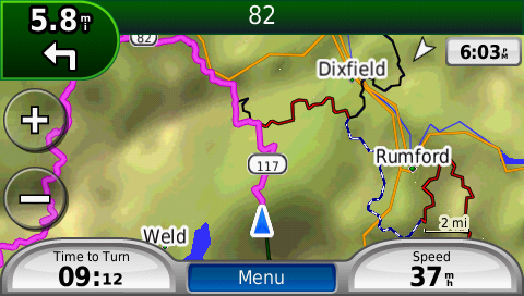
Our Garmin GPS trail maps will give turn by turn directions just like the GPS maps used in your car or truck. See the actual trails, trail names and color-coding for our US and Canada Snowmobile maps and our New England ATV trail maps.
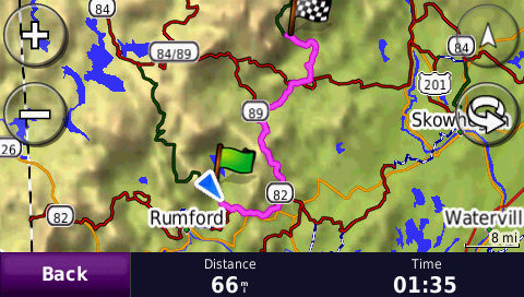
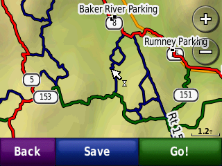
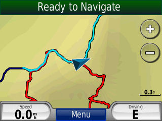
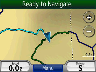
"Auto-routing" or "turn-by-turn" navigation is a capability that is built in to your Garmin GPS. All automotive and many handheld GPS units have this capability. The GPS will treat the trail much like an automotive unit treats roads on an automotive GPS. This will provide you with routable turn by turn directions. The screenshots below illustrate a route by snowmobile trail calculated by the GPS.
Snowmobile Maps
All the maps we sell include both state and club level trail systems. Our trail maps currently combine to cover over 34,700 miles of primary, secondary and club trails in the northeast United States and over 19,800 miles (27,800 km) of provincial and local trails in Quebec and New Brunswick Canada. Combined, our maps include over 5,000 points of interest for trail accessible services (fuel, restaurants, lodging, snowmobile sales, scenic views, trailer parking and snowmobile club houses and warming huts).
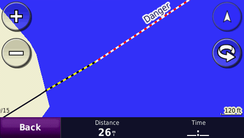
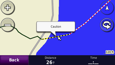
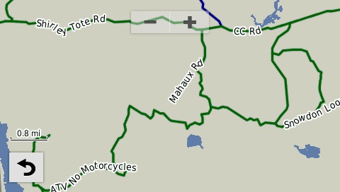
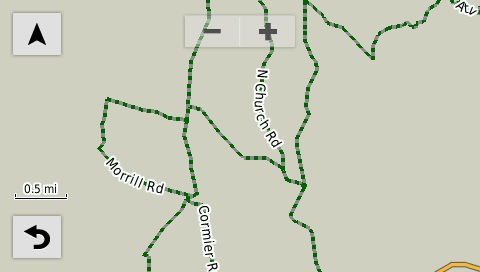
We use different line types for a primary trail, secondary trail, club trail, lake crossing trail, plowed/shared access road, ungroomed trail, closed trail and an approximated trail. For your safety, a yellow/black warning line style for shorelines has been added to every lake crossing. The yellow/black warning stripe line style is designed to warn you when you are approaching the shoreline. The warning stripe indicates you are within 350 feet of the shore.
The warning line style provides added safety at night and in poor visibility conditions often encountered when snowmobiling across large lakes. Always make sure a pond, lake, river or other body of water is safe before driving your snowmobile on it!
With the rider in mind we have color-coded our trails so you can quickly recognize the trail type you are on and easily navigate to your destination.
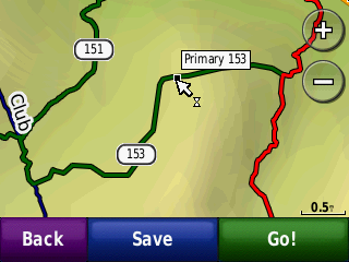
Each state map uses trail and route numbers consistant with the naming in those areas. Trail names and numbers are displayed at different zoom levels based on the model of GPS. Most units won't display the trail names until you are zoomed in quite close.
Click here to view the line style key for the snowmobile maps.

Our snowmobile trail maps for ME, NH, VT, NY & PA are the most current, most accurate and include more miles than any other product on the market. Our snowmobile trail map of Quebec Canada, includes trails in northern New Brunswick.
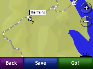
We recognize people like to explore and that not all trails are groomed. These types of trails are uniquely identified by a grey/white striped line style. The trail referred to as "The Trains" in the Moosehead Lake region is one of these trails. ALWAYS check to make sure your riding area is authorized for use!
Our snowmobile GPS trail maps are used primarily the same way as an automotive GPS. Your current position is always shown on the map. While using the routing features, when you come to intersections the GPS will guide you which way to turn. Most GPS units have a trip log feature that will allow you to breadcrumb your ride to follow back or view later. Our GPS maps contain thousands of searchable points of interest for food, fuel, lodging, parking and scenic views.
ATV Maps
Our ATV maps currently cover over 11,000 miles of primary and club trails across Maine, New Hampshire, Vermont, New York and Pennsylvania. In addition there are over 1200 trail accessible points of interest.
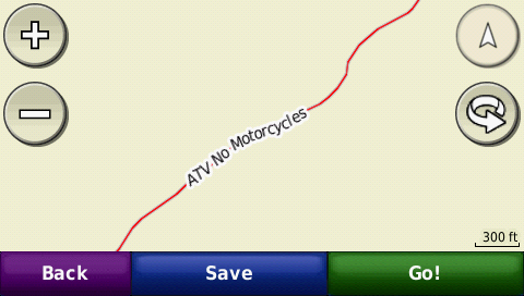
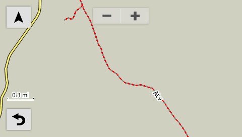
The trails on our ATV GPS maps are color-coded to identify permitted use for different types of OHRVs. Ourline styles distinguish between quad-type ATVs, larger 64" UTV/side by side machines and trail bikes. The color-coded trails help identify locations where your OHRV may not be permitted. We also label every trail with the road name or trail name if known, otherwise a generic "ATV" type label is applied.
ATV trails that are permitted for 64" wide UTV/side by side machines are green. When trail bikes are also permitted the green line style will include a grey stripe. ATV trails that do not allow the wider side by sides are red. Again, if trail bikes are also permitted, the red line style will include a grey stripe. These four line styles are summarized and illustrated below.
Solid Green = UTV, ATV No Trail Bike Green/Grey = UTV, ATV and Trail Bikes permitted
Red = ATV Only Red/Grey = ATV and Trail Bikes permitted
Points of Interest (POI)
Our snowmobile and ATV trail maps for Garmin GPS, iOS and Android devices include THOUSANDS of Points of Interest! On-trail parking, gas, food, lodging, club houses, repair shops, and scenic views. Use our extensive list of POIs to locate services in a pinch.
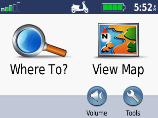
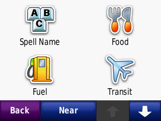
Just as you would in your automobile, the Garmin "Where To?" feature can be used to auto navigate to these points. When the "Where To' feature is pressed, a list of categorized POIs are display as in the middle screenshot below.
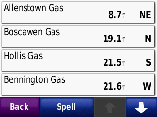
If you are looking for gas, press the "Fuel" icon and you will be shown a list of gas stations ranked in order of closest distance first. You can either select the point of interest and press "Go" to start auto-navigation or you can select the POI and view its location on the map before deciding to calculate a route to that location.